
The best dMRV software is the one a verifier can't argue with
"Best" isn't a feature count. For digital MRV it means every hectare, photo and approval can be traced back to a GPS-locked, timestamped source a verifier will trust. Here's what that looks like — and how TrueCarbon delivers it across every methodology.
- GPS-verified evidence
- Immutable audit trail
- Registry-ready
Almost every dMRV tool can store a form and draw a map. The gap that shows up at verification is evidence integrity — whether the data can be trusted without the verifier taking your word for it. The best dMRV software closes that gap by design: it validates evidence at the point of capture, records every change immutably, and produces a submission package mapped to your registry's requirements. This guide breaks down what to look for, how the workflow fits together, and where TrueCarbon fits for your specific project type.
From field to registry, one traceable chain
Great dMRV isn't a single feature — it's an unbroken chain from the first field visit to the registry submission, where each step verifies the one before it.
- 01
Register
Onboard farmers and plots with duplicate detection on national ID, name similarity and GPS proximity — so the same participant is never counted twice.
- 02
Monitor & capture
Map GPS-verified boundaries with overlap detection, layer remote-sensing signals over them, and capture geo-tagged, in-app-only photos that prove where and when.
- 03
Approve
Route every record through configurable L1 / L2 approvals, where each rejection carries a documented reason and nothing bypasses the workflow.
- 04
Report & submit
Track status on live dashboards, then export a registry-mapped evidence package — one-click CSV, GeoJSON and PDF, every number traceable to a field event.
What separates the best dMRV from the rest
The gap between adequate and audit-proof dMRV shows up in exactly the places a verifier looks first.
Adequate tooling
Stores data
- Photos uploaded from the gallery — no proof of when or where they were taken
- GPS pins instead of verified boundary polygons, with no overlap checks
- Edits overwrite the record; there's no history of what changed or who changed it
- Evidence assembled ad hoc right before an audit, when gaps are expensive to fix
- Reporting compiled by hand across multiple files
Best-in-class dMRV
Proves data
- In-app, GPS-locked, EXIF-validated photo capture only
- Verified boundary polygons with automatic overlap detection
- Append-only audit trail of every submit, approval and rejection with actor and timestamp
- Continuously verification-ready — export an evidence package any time
- Live dashboards and one-click registry-mapped exports
The capabilities that make dMRV audit-proof
Every capability below exists to answer one verifier question: can you prove it? Reuse them across any methodology.
Remote monitoring
Satellite and remote-sensing signals layered over your plots to corroborate field data and flag anomalies.
GPS boundary validation
Verified polygons with automatic overlap detection against every existing plot in the programme.
Geo-tagged evidence
In-app capture only — GPS-locked, timestamped and EXIF-validated before it's accepted.
Immutable audit trail
An append-only record of every action, so nothing can be quietly changed after the fact.
Registry integration
Evidence mapped to registry requirements and exported as a submission-ready package.
Real-time dashboards
Live programme and district views, so status is always legible — never reconstructed.
Offline mobile app
Field teams capture data on-site with no signal; it syncs automatically once back in range.
One-click reporting
CSV, GeoJSON and PDF exports generated on demand, every figure traceable to its source.
Explore dMRV by methodology
Select a methodology to see how its monitoring, evidence, verification and reporting requirements translate into a digital MRV workflow.
AMS-III.AU on TrueCarbon
Applicable project types
Configured for AWD Rice on TrueCarbon — Digitise Alternate Wetting & Drying programmes end-to-end — farmer onboarding, plot boundaries, pipe installation and water-level events — with GPS-verified evidence at every step.
Configured workflow
- 1Register farmers and plots
- 2Install and log AWD pipes
- 3Log water-level events all season
- 4Approve and export
Evidence requirements
- Farmer registration with duplicate detection
- GPS plot boundaries with overlap protection
- Pipe installation with spacing rules
- Water-level events with photo proof
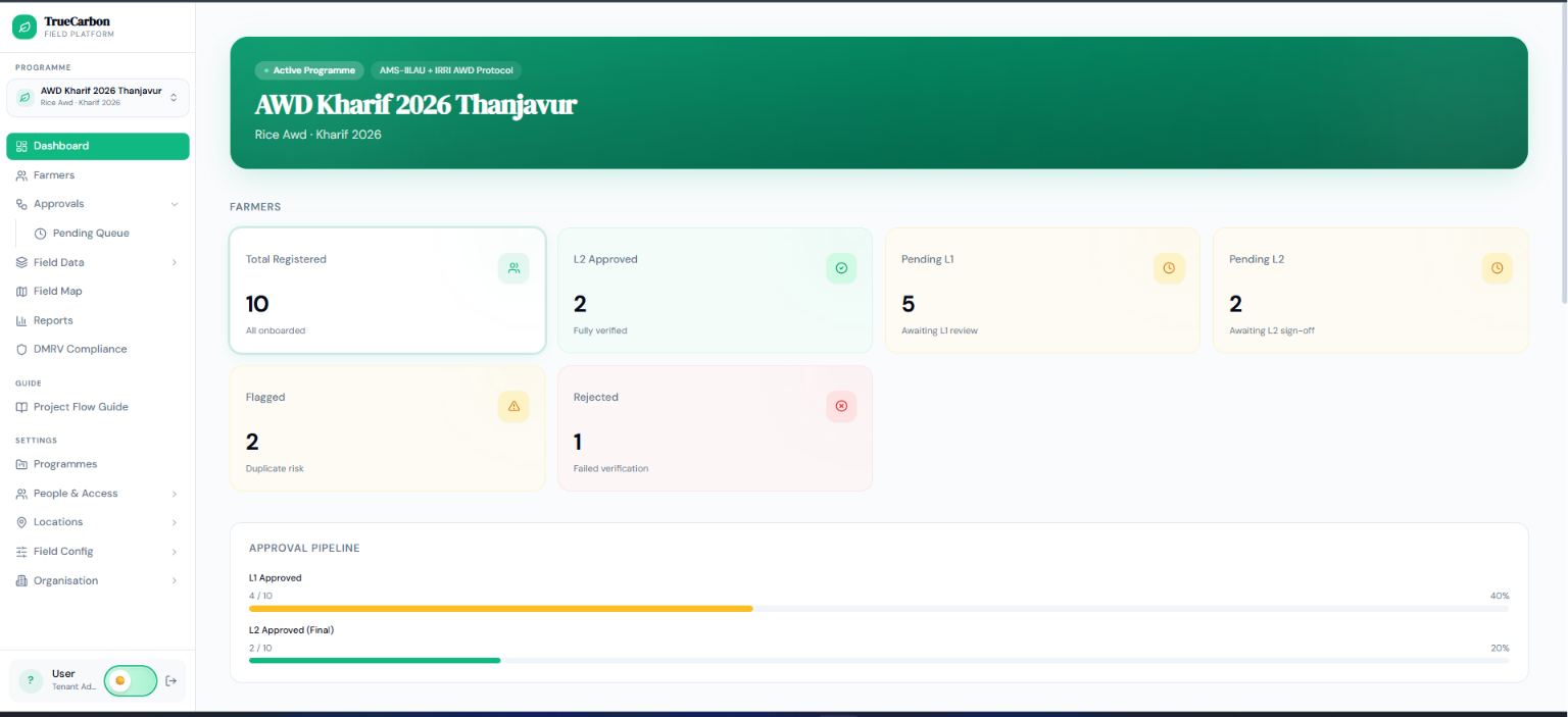
Live TrueCarbon product — AWD Rice programme dashboard.
01/16
The best dMRV for your methodology
The evidence discipline is the same everywhere; the registry specifics differ. Pick your project type for the detail.
What audit-proof dMRV buys you
The payoff of getting evidence right shows up long before the audit.
Fewer verification surprises
Gaps surface continuously, while they're cheap to fix — not in the middle of an audit.
Faster verification cycles
A pre-assembled, registry-mapped evidence package means verifiers spend time reviewing, not chasing.
Credibility that scales
The same evidence standard holds whether you're running one pilot or fifty programmes.
Confident field teams
Clear capture rules and offline support mean less rework and cleaner data from day one.
Defensible decisions
Every approval and rejection is documented, so quality control is a process, not an opinion.
Registry compatibility
Outputs structured for the registries your methodology actually reports to.
Frequently asked questions
Straight answers to the questions programme managers ask most.
What actually makes one dMRV platform "better" than another?
Evidence integrity, not feature count. The best dMRV software validates data at the point of capture (GPS-locked photos, verified boundaries), records every change immutably, and produces registry-ready outputs. Those three things determine whether a dataset survives verification — everything else is convenience.
Is remote sensing or satellite monitoring enough on its own?
No. Remote signals are powerful for corroboration and anomaly detection between field visits, but registries expect ground-truth evidence. The strongest approach layers remote sensing over GPS-verified field data so the two agree — that agreement is what makes the evidence hard to dispute.
How does dMRV reduce the risk of double-counting?
By catching it at registration. TrueCarbon runs duplicate detection on national ID, name similarity and GPS proximity when a participant or plot is added, and detects boundary overlaps automatically — so the same hectare or farmer can't be enrolled twice across field teams.
Do we need to replace our current tools to adopt dMRV?
Usually not all at once. Most programmes start logging new registrations and evidence in TrueCarbon going forward and keep historical records as an archive. We can also import existing participant and plot data as a one-time migration if you want a single system of record from day one.
What does "registry-ready" actually mean?
That you can export an evidence package structured the way your registry expects — with every figure traceable back to a specific field event, actor and timestamp — rather than a raw spreadsheet a verifier has to interpret.
Ready to start
Ready to digitise your carbon programme?
Tell us where you are — scoping, mid-registration or already issuing — and we'll show you exactly what would move onto TrueCarbon.